News
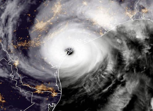
These Terrifying Images Of Hurricane Harvey From Space Reveal How Massive It Really Is

Although Harvey was a Category 4 hurricane in Texas on Friday night, it became a Category 1 storm the next morning. But in spite of this change in strength — the storm's winds went from 130 mph to 80 mph according to hurricane experts — weather forecasters have predicted that the storm will possibly lead to a storm surge and bring torrential rain. Now, with satellite images of Hurricane Harvey shared by social media users on Twitter, it is crystal clear how powerful and breathtaking this storm is.
The storm has been such a cause of concern for weather forecasters that The National Hurricane Center said that it would cause "life-threatening and devastating flooding." In some areas of Texas, the downpour from the storm is expected to cause up to 40 inches of rain which could wash away building signs and even prompt mandatory evacuation for locals.
In addition to that, there is a storm surge warning in effect for the Baffin Bay and High Island areas of Texas where it is predicted that the storm will cause a rapid increase in water. Weather specialists expect that the storm may leave some 1.3 million Texans without electricity due to power lines and trees struck down by its incredible winds.
1. "Strongest-Looking"
Some have commented on the undeniable magnitude of the storm.
2. Compared To Hurricane Katrina
Images of the storm juxtaposed against Hurricane Katrina from 2005 revealed the similarities between both.
3. Making Landfall In Texas
Another satellite image showed the storm making landfall in Texas. A landfall takes place when a storm enters land after being over water.
4. On The Texas Coastline
This satellite image showed the storm hovering over Texas' coast.
5. A Kind Of Satellite Image You "Don't Want To See"
Several commented on how alarming the images of Harvey were.
6. Watch As It Strengthens
This particular satellite image showed how Harvey took on even more strength. It's a menacing and intimidating visual worth looking at.
7. Inching To The Coast
Another image of Harvey on the coastline.
8. Eye Of The Storm
This satellite image showed Harvey from Friday night.
9. Massive Wind
"Eye-popping" indeed.
10. Hurricane Harvey In Its Category 4 Form
An image of a Category 4 Harvey over Texas.
11. Watch As Its Colors Intensify
Another image of Harvey gaining more and more strength.
12. Alarming
Core winds revealed in this satellite image.
13. "Absolutely Unreal"
Some believe that the Harvey will alter the shape of Texas' coast due to its strength.
14. Infrared Satellite Imagery
Infrared imagery of Harvey showed how the storm approached the Texas coastline.
15. Enhanced Infrared Satellite Imagery
An image of Harvey from Friday noon.
Although Harvey has been repeatedly described as dangerous and potentially fatal, there's no need to panic. Locals have been provided ample information by the Texas Department of Transportation as to how they best prepare themselves for the storm and its aftermath.